
Santa Rosa, CA — Bay Area transit agencies, alongside the Metropolitan Transportation Commission (MTC), have unveiled new test transit maps and signage aimed at making it easier for both existing and new riders to navigate public transportation. The new wayfinding materials were recently installed at the Santa Rosa Transit Mall and the downtown Sonoma-Marin Area Rail Transit (SMART) station, marking a significant step in the broader Regional Mapping and Wayfinding initiative.
The goal of this initiative is to provide Bay Area commuters with a seamless and consistent transit experience, whether they are traveling by bus, rail, ferry, or a combination of services. The new signs, maps, and communication systems are designed to make transit journeys more intuitive and accessible across all nine Bay Area counties.
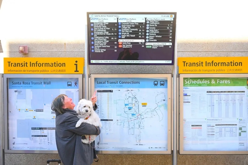
Santa Rosa Joins the Pilot Program
Santa Rosa is the second city to pilot these new wayfinding materials. The first location to feature the redesigned signage was the El Cerrito del Norte BART station, which received similar updates in December 2024. These tests are part of a larger effort to harmonize transit maps and signage across the Bay Area, making public transportation easier to navigate for all riders.
The updated signage in Santa Rosa focuses on providing clear, predictable, and familiar information, helping riders navigate the half-mile route between the downtown SMART station and the Transit Mall. The directional signs are designed to be easy to follow and to ensure consistency for commuters traveling across county lines.
A Step Forward for Santa Rosa’s Transit System
At the unveiling of the new signage, Santa Rosa Mayor Mark Stapp expressed pride in the city’s selection as a test location. “This marks a significant step forward in our commitment to creating a more seamless, accessible, and user-friendly transit system for Santa Rosa and the greater Bay Area,” Stapp said.
The installation of these signs is seen as a response to feedback from transit riders, many of whom have expressed difficulty navigating the route between the SMART station and the Transit Mall. By improving the clarity of signage and mapping, the new system aims to reduce confusion and make it easier for commuters to find their way.
Public Input Encouraged
Public feedback will play a crucial role in shaping the next phase of the project. Victoria Fleming, Santa Rosa City Councilmember and MTC Commissioner, highlighted the importance of rider input in refining the materials. “Starting this week, North Bay transit riders will be able to use the test maps and signs here at the Transit Mall and the downtown SMART station and share their ideas about how to make the new materials work better for them,” she said. “We’re doing this work not only to improve the system for current riders, but to try to encourage more people to ride transit.”
For those unable to visit the test locations in Santa Rosa or El Cerrito, an online survey has been made available. Feedback gathered will help inform the installation of additional wayfinding materials across the Bay Area in 2025 and 2026.
A Collaborative Effort for Better Transit
The Regional Mapping and Wayfinding project is part of a groundbreaking collaboration between MTC, Bay Area cities and counties, and over two dozen regional transit agencies. The goal of the initiative is to redesign and harmonize transit signage and maps, making it easier for residents to navigate transit systems across the Bay Area.
Chris Coursey, Sonoma County Supervisor and SMART Board member, expressed optimism about the new wayfinding materials. “For years, we’ve heard from riders that navigating between SMART’s Santa Rosa Downtown station and the Santa Rosa Transit Mall can be challenging. By improving signage and mapping, we are breaking down barriers and making transit more intuitive,” he said.
The initiative is part of the Bay Area Transit Transformation Action Plan, which aims to make transit more convenient for people of all ages and abilities. As part of this effort, MTC and local transit agencies are working to create a system that is easier to use and more accessible to everyone.
Looking Ahead
The MTC Regional Mapping and Wayfinding initiative is a significant component of a broader effort to modernize public transit in the Bay Area. With further installations and refinements planned over the next few years, the hope is that these improvements will make it easier for more people to rely on public transportation, whether for daily commutes, medical appointments, or leisure travel. As the project moves forward, input from the public will continue to be crucial in shaping the future of Bay Area transit.